A view from above
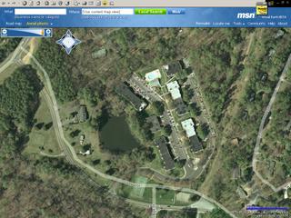
Found this cool website recently: http://virtualearth.msn.com/. It provides amazing detail for places in U.S. (They don't have such detailed data for India as yet.) We can zoom into any place, and if you select the aerial photo option, then it gives pretty good detail of the actual buildings.
 The place where I moved to after my studies...The Heights in Redmond, WA.
 And this is the aerial view of India!

Google also has a software called Google Earth (http://earth.google.com/), that you can install on your PC and see the same views as above...the earth animation and "fly into" option make it a lot cooler to use, but it seems a bit slower.
This is where I did my studies: Chapel Hill, NC. The place below is Bolinwood Apartments, where I used to live. (Can even see the tennis court, where I used to play tennis!)
 The place where I moved to after my studies...The Heights in Redmond, WA.
 And this is the aerial view of India!
Google also has a software called Google Earth (http://earth.google.com/), that you can install on your PC and see the same views as above...the earth animation and "fly into" option make it a lot cooler to use, but it seems a bit slower.


0 Comments:
Post a Comment
<< Home